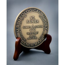
Mt Rainier Summit Markers to commemorate your climb or visit Located in Washington State, Mt Rainier is a national landmark!
Mount Rainier is a massive stratovolcano located 54 miles (87 km) southeast of Seattle in the state of Washington, United States. It is the most topographically prominent mountain in the contiguous United States and the Cascade Volcanic Arc, with a summit elevation of 14,411 ft (4,392 m). Mt. Rainier is considered one of the most dangerous volcanoes in the world, and it is on the Decade Volcano list. Because of its large amount of glacial ice, Mt. Rainier could potentially produce massive lahars that would threaten the whole Puyallup River valley.
Mount Rainier is the highest mountain in Washington and the Cascade Range. Mount Rainier has a topographic prominence of 13,211 ft (4,027 m), greater than K2 at 13,189 ft (4,020 m). On clear days it dominates the southeastern horizon in most of the Seattle-Tacoma metropolitan area to such an extent that locals sometimes refer to it simply as "the Mountain." On days of exceptional clarity, it can also be seen from as far away as Portland, Oregon and Victoria, British Columbia.
The broad top of Mount Rainier contains three named summits. The highest is called the Columbia Crest. The second highest summit is Point Success, 14,158 ft (4,315 m), at the southern edge of the summit plateau, atop the ridge known as Success Cleaver. It has a topographic prominence of about 138 ft (42 m), so it is not considered a separate peak. The lowest of the three summits is Liberty Cap, 14,112 ft (4,301 m), at the northwestern edge, which overlooks Liberty Ridge, the Sunset Amphitheater, and the dramatic Willis Wall. Liberty Cap has a prominence of 492 ft (150 m), and so would qualify as a separate peak under most of strictly prominence-based rules. A prominence cutoff of 400 ft (122 m) is commonly used in Washington state.
Mt Rainier
- Brand: Mt Rainier
- Product Code: 91
- Availability: 17
-
$29.95
- Price in reward points: 30
Available Options
Related Products
Death Valley
Death Valley (Badwater Basin) is the lowest point in the lower 48, Death Valley is less than 1..
$29.95
Mt Whitney
Mt. Whitney Looms over Death Valley, California - the lowest point in the United states ? less than ..
$29.95


